PARADISE ON FIRE – 2023 Hawaii Wildfire: Cost-Effective Rapid Wildfire Analysis

Presenters:
Zongrong Li
Qiluo Li
Haiyang Li
University of Southern California
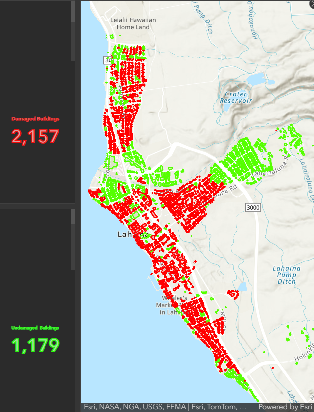
This project provides a detailed analysis of the 2023 Hawaii wildfires, with a specific focus on Maui. Our goal is to uncover insights critical to developing effective wildfire management and mitigation strategies, especially in the context of changing climate conditions.
Our approach is divided into three layers. First, we performed a macroscopic analysis using the Fire Information Resource Management system (FIRM) to identify large-scale burned areas at approximately 1 km resolution. The second phase includes intermediate analysis using Sentinel 2 data, which despite its 20-meter resolution is critical for early assessment of burn time and area. The final phase involved microscopic analysis using Planet’s high-resolution (3m) satellite data, focusing on the impact on vegetation cover through the NDVI index. A unique feature of our approach is the use of Google Earth Engine (GEE) for comprehensive analysis and Geemap for visualization of Web interactive maps.
The result of this research is the implementation of an innovative approach to wildfire detection and the ability to perform real-time impact assessment, providing an interactive and immersive experience for understanding the dynamics of wildfires. This understanding is critical to developing strong strategies for future wildfire management and community safety in Hawaii.